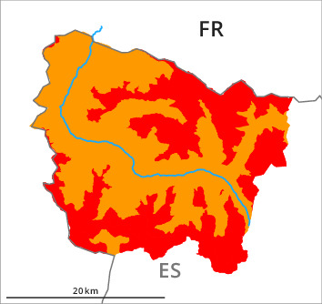
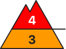
Danger level
2000m
Avalanche Problem

Wet snow

2000m


Wind-drifted snow
2000m

As a consequence of rain a high danger of moist and wet avalanches will prevail.
Wet snow represents the main danger. On wind-loaded slopes a critical avalanche situation will prevail.
As a consequence of the rain numerous medium-sized and, in isolated cases, large natural moist avalanches are to be expected below approximately 2300 m. As a consequence of the precipitation the prevalence and size of the avalanche prone locations will increase as the day progresses.
The fresh and older wind slabs of last week can be released very easily in particular on steep shady slopes and at intermediate and high altitudes. The avalanche prone locations are to be found in particular in steep terrain at elevated altitudes.
Gliding avalanches can be released at any time of day or night.
Snowpack
>Up to 2200 m rain fell during the night over a wide area. The rain will give rise as the day progresses to rapid moistening of the snowpack over a wide area below approximately 2200 m. The surface of the snowpack is not frozen and will already be soft in the early morning.
The wind will be moderate to strong adjacent to ridgelines. In some places various wind slab layers are lying on old snow containing large grains. This applies especially above approximately 2200 m and in the southern area of Aran.
The conditions are unfavourable for backcountry touring and other off-piste activities.
Tendency
The danger of moist avalanches will decrease gradually.