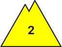
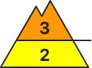
Danger level
2000m
Avalanche Problem

Wind-drifted snow

2000m

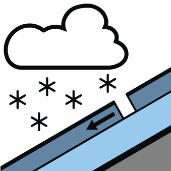
New snow

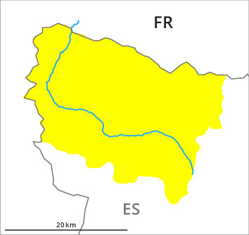
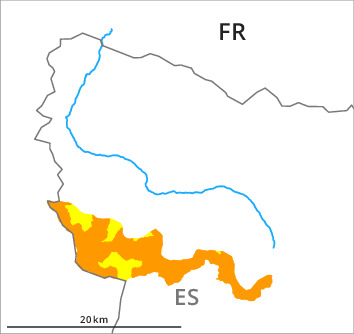
Valleys of Molières and Conangles, and southern border of Aran: The conditions are critical for winter sport activities in steep terrain.
As a consequence of new snow and wind a considerable danger of dry avalanches will prevail. The fresh snow and in particular the extensive wind slabs that are forming over a wide area can be released easily or naturally in particular on steep north, east and south facing slopes and in all altitude zones. Mostly the avalanches in these loacations are medium-sized. The prevalence of the avalanche prone locations will increase with altitude.
Snow sport activities are to be restricted to moderately steep terrain as far as possible.
Snow sport activities are to be restricted to moderately steep terrain as far as possible.
Snowpack
>10 to 20 cm of snow fell in the last few days. The southwesterly wind has transported the new snow significantly. The new snow and wind slabs are lying on soft layers in all aspects. In the valleys of Molières and Conangles and at the divide with Pallaresa 20 to 25 cm of snow will fall in the next few hours in all altitude zones. On Wednesday the wind will be moderate to strong over a wide area. The northwesterly wind will transport the new snow and, in some cases, old snow as well. These meteorological conditions will foster a gradual rise in the avalanche danger as the day progresses in all aspects.
Tendency
Rapid increase in danger of moist avalanches as a consequence of warming during the day and solar radiation.