Danger level
2000m
Avalanche Problem

Wind-drifted snow

2000m


Wet snow

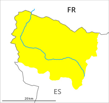
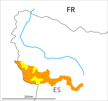
Valleys of Molières and Conangles, and southern border of Aran: The conditions are critical for winter sport activities in steep terrain. Wind slabs and wet snow represent the main danger.
The fresh snow and in particular the extensive wind slabs that are forming over a wide area can be released easily, or, in isolated cases naturally in particular on steep north, east and south facing slopes and at intermediate and high altitudes. Mostly the avalanches in these loacations are medium-sized. The prevalence of the avalanche prone locations will increase with altitude.
In addition from midday on west, south and southeast facing slopes, an increasing number of small and medium-sized natural moist avalanches are to be expected. Gliding avalanches are also to be expected.
Snow sport activities are to be restricted to moderately steep terrain as far as possible.
In addition from midday on west, south and southeast facing slopes, an increasing number of small and medium-sized natural moist avalanches are to be expected. Gliding avalanches are also to be expected.
Snow sport activities are to be restricted to moderately steep terrain as far as possible.
Snowpack
>25 to 30 cm of snow, and even more in some localities, fell in the last four days. The southwesterly wind has transported the new snow significantly. The new snow and wind slabs are lying on soft layers in all aspects.
Sunshine and high temperatures will give rise from the middle of the day to rapid moistening of the snowpack on steep sunny slopes in all altitude zones.
Sunshine and high temperatures will give rise from the middle of the day to rapid moistening of the snowpack on steep sunny slopes in all altitude zones.
Tendency
Intermediate and high altitudes: Slight increase in danger of dry avalanches as a consequence of the new snow. Low altitudes: Increase in danger of gliding avalanches and moist snow slides as a consequence of the rain.