AM
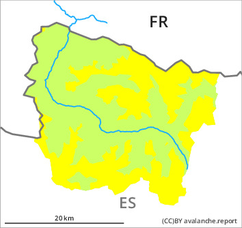
Danger level

2100m
Avalanche Problem

New snow

2100m

PM
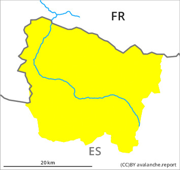
Danger level

2200m
Avalanche Problem

Wind slab
2200m

New snow

New snow and wind slabs at intermediate and high altitudes.
5 to 15 cm of snow will fall until late in the night above approximately 2000 m. This snow can be released easily, or, in isolated cases, naturally in all aspects and at intermediate and high altitudes.
As a consequence of a gathering strong northwesterly wind, precarious wind slabs will form in the course of the day in particular on north, east and south facing slopes. These can be released by people or triggered naturally. Avalanches are rather small.
The avalanche prone locations are barely recognisable because of the poor visibility. Ski touring and other off-piste activities, including snowshoe hiking, call for caution.
Snowpack
>
The fresh snow and the wind slabs will be deposited on the unfavourable surface of an old snowpack in particular on north and east facing slopes above approximately 2000 m.
Above approximately 2000 m there are 20 to 30 cm of snow, and even more in some localities. Snow depths vary greatly, depending on the infuence of the wind. At low altitude from a snow sport perspective, insufficient snow is lying.
Above approximately 2000 m there are 20 to 30 cm of snow, and even more in some localities. Snow depths vary greatly, depending on the infuence of the wind. At low altitude from a snow sport perspective, insufficient snow is lying.
Tendency
On Saturday as a consequence of the rain there will be a rapid increase in the danger of moist avalanches to level 3 (considerable).