Danger level

treeline
Avalanche Problem

Wind slab

Treeline


Persistent weak layer
2000m

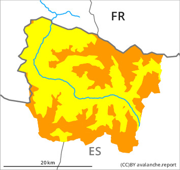
The avalanche conditions remain dangerous. Especially at the southern border of Aran the avalanche prone locations are more prevalent and the danger is greater.
New snow and wind slabs. Weakly bonded old snow on shady slopes.
Fresh and somewhat older wind slabs are to be found in all aspects. As a consequence of new snow and a moderate wind from northwesterly directions, further wind slabs will form in the course of the day. They can be released by people or triggered naturally. In many cases the avalanches are medium-sized.
Faceted weak layers exist in the bottom section of the snowpack on shady slopes. Especially transitions from a shallow to a deep snowpack: Weak layers in the old snowpack can be released easily. In particular at intermediate and high altitudes they are sometimes large.
The new snow can be released easily, or, in isolated cases, naturally in all altitude zones. Dry snow slides and avalanches are possible, even medium-sized ones. Individual gliding avalanches can also occur.
At the border to Ribagorça and Pallars the avalanche prone locations are more prevalent and the danger is slightly greater. Backcountry touring and other off-piste activities call for extensive experience in the assessment of avalanche danger.
Snowpack
>
Distinct weak layers exist in the bottom section of the old snowpack in particular on rather lightly snow-covered west, north and east facing slopes. Released avalanches and stability tests confirm the complex avalanche situation in all regions.
Saturday: In some regions 15 to 20 cm of snow will fall. The northwesterly wind will transport the new snow.
At intermediate altitudes there are 100 to 140 cm of snow, and even more in some localities. At elevated altitudes snow depths vary greatly, depending on the infuence of the wind.
Saturday: In some regions 15 to 20 cm of snow will fall. The northwesterly wind will transport the new snow.
At intermediate altitudes there are 100 to 140 cm of snow, and even more in some localities. At elevated altitudes snow depths vary greatly, depending on the infuence of the wind.
Tendency
Sunday: The weather will be sunny at times. The avalanche danger will persist.