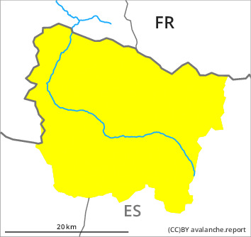
Danger level

Avalanche Problem
Gliding snow


Wet snow
Wet and gliding snow represent the main danger.
On steep grassy slopes medium-sized and, in isolated cases, large gliding avalanches are to be expected. Sunny slopes and low and intermediate altitudes: As the penetration by moisture increases small and medium-sized dry and moist snow slides are to be expected. Moist avalanches can in some places be released in the weakly bonded old snow in particular on shady slopes.
Also adjacent to ridgelines and in gullies and bowls: The wind slabs can be released by a single winter sport participant in isolated cases at high altitude.
Backcountry touring and other off-piste activities call for meticulous route selection. Areas with glide cracks are to be avoided.
Also adjacent to ridgelines and in gullies and bowls: The wind slabs can be released by a single winter sport participant in isolated cases at high altitude.
Backcountry touring and other off-piste activities call for meticulous route selection. Areas with glide cracks are to be avoided.
Snowpack
>
Evening: Some rain will fall.
Thursday: The weather will be cloudy. The southeasterly wind will transport only a little snow. The surface of the snowpack will only just freeze and will soften during the day. Midday and afternoon: Up to 2300 m rain will fall in particular at the southern and eastern borders of Aran. Especially sunny slopes and low and intermediate altitudes: These weather conditions will give rise to increasing moistening of the snowpack over a wide area.
Shady slopes intermediate and high altitudes: In its middle, the snowpack is well consolidated. Towards its base, the snowpack is weak. At intermediate altitudes there are 150 to 200 cm of snow, and even more in some localities.
Tendency
Friday: The avalanche danger will persist.