EARLIER
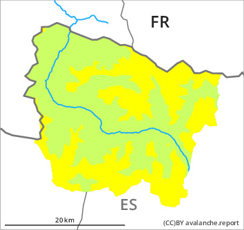
Danger level

2400m
Avalanche Problem

Persistent weak layer

2400m


Wet snow


LATER
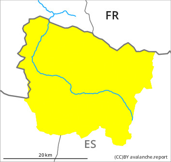
Danger level

2400m
Avalanche Problem
Persistent weak layer
2400m
Wet snow

Weakly bonded old snow requires caution. Moist snow slides as the day progresses.
High altitudes, steep shady slopes: Weak layers in the upper part of the snowpack can still be released in some places. Sometimes the dry avalanches are medium-sized and can be released by a single winter sport participant. Caution is to be exercised adjacent to ridgelines and in gullies and bowls, as well as at the base of rock walls and behind abrupt changes in the terrain. In particular adjacent to ridgelines and in pass areas: In addition the small wind slabs must be taken into account.
Very steep sunny slopes as well as low altitudes: As a consequence of warming during the day and solar radiation more moist snow slides are to be expected as the day progresses, but they will be mostly small. Moist avalanches can occur easily or triggered naturally. Gliding avalanches can also occur.
The current avalanche situation calls for experience in the assessment of avalanche danger and restraint.
Snowpack
>
In particular high altitudes in shady places that are protected from the wind: Large-grained weak layers exist in the top section of the snowpack. Stability tests indicate the unfavourable bonding of the snowpack in these regions.
On Tuesday it will be sunny. The surface of the snowpack will freeze to form a strong crust and will soften during the day.
At intermediate altitudes there are 150 to 200 cm of snow, and even more in some localities. Snow depths vary greatly at high altitudes and in high Alpine regions, depending on the infuence of the wind.
Tendency
The avalanche danger will persist.