Danger level

treeline
Avalanche Problem

Wind slab

Treeline


Persistent weak layer
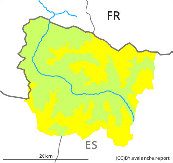
2300m

Wind slabs and weakly bonded old snow require caution.
As a consequence of new snow and a moderate to strong northwesterly wind, mostly small wind slabs formed adjacent to ridgelines and in gullies and bowls as well as above the tree line. Individual medium-sized avalanches are further not ruled out. The clearly visible wind slabs can be released in some cases. Intermediate and high altitudes, steep shady slopes: The wind slabs have bonded very poorly.
Weak layers in the old snowpack can be released in some places by people especially on wind-protected shady slopes. Sometimes they are medium-sized. Caution is to be exercised in particular in little used backcountry terrain at the base of rock walls and behind abrupt changes in the terrain.
The current avalanche situation calls for experience in the assessment of avalanche danger.
Snowpack
>
On Saturday it will be cold. In the early morning the weather will be partly cloudy. The wind will be light to moderate adjacent to ridgelines. Down to low altitudes snow will fall from the afternoon.
In particular intermediate and high altitudes, in shady places that are protected from the wind: In some places wind slabs are lying on surface hoar. Large-grained weak layers exist in the top section of the snowpack in particular above approximately 2300 m. Released avalanches and stability tests indicate the unfavourable bonding of the snowpack in these regions.
At intermediate altitudes there are 100 to 200 cm of snow, and even more in some localities. Snow depths vary greatly at high altitudes and in high Alpine regions, depending on the infuence of the wind.
Tendency
Evening and night: Significant increase in danger of dry avalanches as the snowfall becomes more intense.