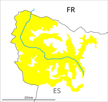
Danger level
2100m
Avalanche Problem

Wind-drifted snow

2100m


Wet snow
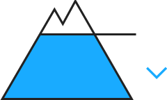
2100m

New snow and wind slabs at intermediate and high altitudes. Below approximately 2000 m gliding avalanches and moist snow slides are to be expected.
As the snowfall level rises numerous wet and gliding avalanches are to be expected by midday, but they can reach medium size in isolated cases. The avalanche prone locations are to be found especially in steep rocky terrain and on very steep grassy slopes below approximately 2100 m.
In particular adjacent to ridgelines and in gullies and bowls the wind slabs will increase in size additionally as the day progresses. The avalanche prone locations are to be found in particular adjacent to ridgelines and in gullies and bowls above approximately 2000 m. The fresh and somewhat older wind slabs are in some cases prone to triggering. In isolated cases the avalanches can be released in the various wind slab layers and reach medium size.
In particular adjacent to ridgelines and in gullies and bowls the wind slabs will increase in size additionally as the day progresses. The avalanche prone locations are to be found in particular adjacent to ridgelines and in gullies and bowls above approximately 2000 m. The fresh and somewhat older wind slabs are in some cases prone to triggering. In isolated cases the avalanches can be released in the various wind slab layers and reach medium size.
Snowpack
>60 to 80 cm of snow, and even more in some localities, has fallen since Friday above approximately 1800 m. Adjacent to ridgelines in all aspects as well as at high altitudes and in high Alpine regions snow depths vary greatly, depending on the infuence of the wind. The new snow is lying on soft layers on shady slopes at high altitude. The rain gave rise during the night to rapid moistening of the snowpack in all aspects below approximately 2200 m.
Backcountry touring calls for experience in the assessment of avalanche danger and restraint.
Backcountry touring calls for experience in the assessment of avalanche danger and restraint.
Tendency
Slight increase in avalanche danger as a consequence of new snow and strong wind.