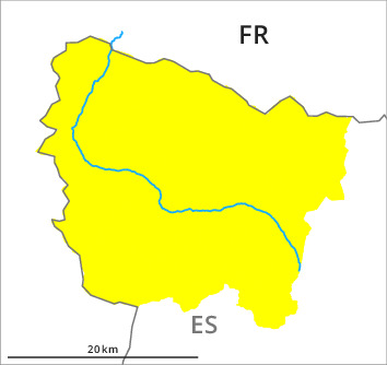
Danger level
2000m
Avalanche Problem

Wind-drifted snow

2000m


Wet snow
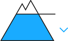
2000m

Wet and gliding snow at low altitude. Wind slabs at intermediate and high altitudes.
The somewhat older wind slabs are to be found adjacent to ridgelines on north and east facing slopes. They are mostly small and can only be released in isolated cases. As a consequence of new snow and a freshening northwesterly wind, mostly small wind slabs will form from the middle of the day in particular adjacent to ridgelines on northeast, east and south facing slopes. These can be released by a single winter sport participant.
In addition as the day progresses at low altitude, some small wet and gliding avalanches are to be expected.
The current avalanche situation calls for experience in the assessment of avalanche danger and a certain restraint.
In addition as the day progresses at low altitude, some small wet and gliding avalanches are to be expected.
The current avalanche situation calls for experience in the assessment of avalanche danger and a certain restraint.
Snowpack
>On Thursday it was warm over a wide area. 10 to 15 cm of snow, and even more in some localities, will fall until Saturday above approximately 1800 m. The wind will be moderate to strong for a temporary period in particular on the peaks and ridges of the divide with the Ribagorçana basin and the Pallaresa basin.
The new snow and wind slabs of the last four days are in individual cases still prone to triggering above approximately 2000 m.
Outgoing longwave radiation during the night will be severely restricted. The surface of the snowpack will freeze very little and will soften quickly. The sleet will give rise from midday to significant moistening of the snowpack in all aspects below approximately 2000 m.
Tendency
Once the rainfall has ended, the avalanche activity will gradually increase.