Danger level
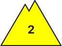
2000m
Avalanche Problem

Wind-drifted snow

2000m


Wet snow
1800m

Wind slabs represent the main danger. Moist snow slides in the middle of the day.
As a consequence of new snow and a strengthening northwesterly wind, mostly small wind slabs will form by the early morning in particular adjacent to ridgelines on northeast, east and south facing slopes. These can in many cases be released easily. The somewhat older wind slabs are to be found adjacent to ridgelines on north and east facing slopes and generally at high altitudes. They are mostly small but in some cases prone to triggering. In gullies and bowls, and behind abrupt changes in the terrain these can be released in the new snow and wind slab layers and reach medium size in some cases.
On very steep sunny slopes and at intermediate and high altitudes moist snow slides are possible in the middle of the day, but they will be mostly small.
The current avalanche situation calls for experience in the assessment of avalanche danger and careful route selection.
On very steep sunny slopes and at intermediate and high altitudes moist snow slides are possible in the middle of the day, but they will be mostly small.
The current avalanche situation calls for experience in the assessment of avalanche danger and careful route selection.
Snowpack
>Over a wide area 10 to 15 cm of snow, and even more in some localities, will fall until Saturday above approximately 1800 m. The wind will be moderate to strong in some localities in particular on the peaks and ridges of the divide with the Ribagorçana basin and the Pallaresa basin. The wind will transport the new snow.
The somewhat older wind slabs will be covered with new snow in some cases and therefore difficult to recognise.
At low altitude from a snow sport perspective, insufficient snow is lying.
The somewhat older wind slabs will be covered with new snow in some cases and therefore difficult to recognise.
At low altitude from a snow sport perspective, insufficient snow is lying.
Tendency
Gradual decrease in danger of dry avalanches. Significant increase in danger of moist avalanches as a consequence of warming during the day and solar radiation.