Danger level
2300m
Avalanche Problem

Wind-drifted snow

2300m


Wet snow
2200m

Wind slabs at high altitude. In the middle of the day, a few moist snow slides are possible.
As a consequence of a light to moderate wind from northwesterly directions, small wind slabs formed by the early morning adjacent to ridgelines on northeast, east and southeast facing slopes. They can be released by a single winter sport participant in isolated cases at high altitude.
In the middle of the day the likelihood of moist snow slides being released will increase a little in particular on very steep south facing slopes at intermediate and high altitudes.
Restraint should be exercised because avalanches can sweep people along and give rise to falls.
In the middle of the day the likelihood of moist snow slides being released will increase a little in particular on very steep south facing slopes at intermediate and high altitudes.
Restraint should be exercised because avalanches can sweep people along and give rise to falls.
Snowpack
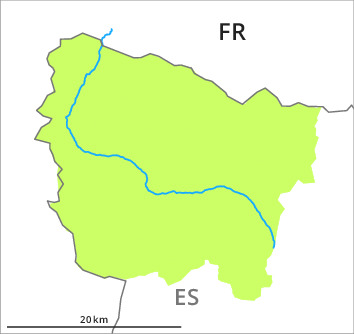
>Over a wide area 2 to 5 cm of snow fell yesterday above approximately 2000 m.
Shady slopes and adjacent to ridgelines: The snowpack is favourably layered and its surface consists of loosely bonded snow lying on a strong crust.
Sunny slopes: The surface of the snowpack has frozen to form a strong crust and will soften during the day.
At low altitude from a snow sport perspective, in most cases insufficient snow is lying.
Tendency
As a consequence of new snow and strong wind the prevalence and size of the avalanche prone locations will increase from the early morning.