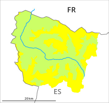
Danger level
2300m
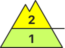
Avalanche Problem

Wind-drifted snow

2300m

Wind slabs represent the main danger.
As a consequence of new snow and a moderate to strong wind from northwesterly directions, clearly visible wind slabs formed since Sunday in particular adjacent to ridgelines and in gullies and bowls. These can in some places be released by people, but they will be small in most cases. On wind-protected shady slopes Explanation: "these" may only stand for "these avalanches" can be triggered in the faceted old snow and reach medium size in isolated cases. As a consequence of a strengthening northerly wind, further wind slabs will form in the course of the day in particular adjacent to ridgelines on east, south and west facing slopes.
Fresh and somewhat older wind slabs must be evaluated with care and prudence. Apart from the danger of being buried, restraint should be exercised in particular in view of the danger of avalanches sweeping people along and giving rise to falls.
Fresh and somewhat older wind slabs must be evaluated with care and prudence. Apart from the danger of being buried, restraint should be exercised in particular in view of the danger of avalanches sweeping people along and giving rise to falls.
Snowpack
>Up to 5 cm of snow has fallen since Sunday above approximately 2000 m. The northwesterly wind has transported the new snow and, in some cases, old snow as well. Some fresh snow and the scattered mostly small wind slabs are poorly bonded with the old snowpack in particular on wind-protected shady slopes above approximately 2000 m.
In its middle, the snowpack is largely stable. At intermediate and high altitudes snow depths vary greatly, depending on the infuence of the wind. At low altitude from a snow sport perspective, in most cases insufficient snow is lying.
In its middle, the snowpack is largely stable. At intermediate and high altitudes snow depths vary greatly, depending on the infuence of the wind. At low altitude from a snow sport perspective, in most cases insufficient snow is lying.
Tendency
Gradual increase in danger of dry avalanches as the snowfall becomes more intense.