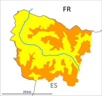
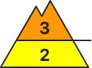
Danger level
2200m
Avalanche Problem

Wind-drifted snow

2200m

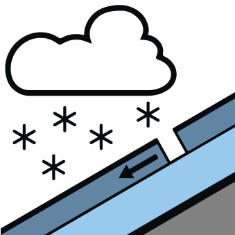
New snow
2000m

New snow and wind slabs represent the main danger. At intermediate and high altitudes a considerable danger will persist.
The cold fresh snow of Friday and in particular the extensive wind slabs can be released easily or naturally in all aspects above approximately 2000 m. The avalanche prone locations are to be found in particular on wind-protected shady slopes at intermediate and high altitudes and on wind-loaded slopes above approximately 2200 m. These can in many places be released by small loads and reach medium size. In addition further wind slabs will form in particular adjacent to ridgelines on east, south and west facing slopes from the late morning. As a consequence of solar radiation dry snow slides and avalanches are to be expected as the day progresses, but they will be mostly small.
Backcountry touring and other off-piste activities call for experience in the assessment of avalanche danger and careful route selection.
Backcountry touring and other off-piste activities call for experience in the assessment of avalanche danger and careful route selection.
Snowpack
>Over a wide area 20 to 30 cm of snow, and even more in some localities, has fallen above approximately 2000 m. Up to 10 cm of snow will fall until late morning. The northerly wind will transport the new snow significantly. The cold fresh snow and all the wind slabs are lying on top of a quite favourable old snowpack in all aspects.
At intermediate and high altitudes snow depths vary greatly, depending on the infuence of the wind. At low altitude from a snow sport perspective, in most cases insufficient snow is lying.
At intermediate and high altitudes snow depths vary greatly, depending on the infuence of the wind. At low altitude from a snow sport perspective, in most cases insufficient snow is lying.
Tendency
Slight decrease in danger of dry avalanches as the snowfall eases. As a consequence of a sometimes strong northeasterly wind, further wind slabs will form on Sunday.