Danger level
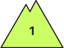
2600m
Avalanche Problem

Wet snow
2600m

As a consequence of heat and rain an unfavourable avalanche situation will be encountered in some localities.
As the temperature drops a favourable early-morning avalanche situation will persist. The spring-like weather conditions from the early morning will give rise to increasing moistening of the snowpack in some places in all aspects below approximately 2600 m. As the penetration by moisture increases moist snow slides and avalanches are possible, but they will be mostly small.
Weak layers in the old snowpack can be released in very isolated cases also on steep, rather lightly snow-covered shady slopes.
Weak layers in the old snowpack can be released in very isolated cases also on steep, rather lightly snow-covered shady slopes.
Snowpack
>All aspects: The snowpack is largely stable and its surface has a melt-freeze crust that is strong in many cases.
On steep sunny slopes and below approximately 2600 m the snowpack will soften during the day. Steep, little used shady slopes high altitudes and the high Alpine regions: The snowpack remains weakly bonded in particular in areas where the snow cover is rather shallow.
In some localities up to 2 cm of snow will fall from midday above approximately 2000 m. The light wind will transport only a little snow.
In all regions at intermediate and high altitudes less snow than usual is lying. At low altitude from a snow sport perspective, in most cases insufficient snow is lying.
Tendency
As a consequence of the rain the avalanche prone locations will become more prevalent on Saturday.