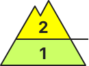
Danger level
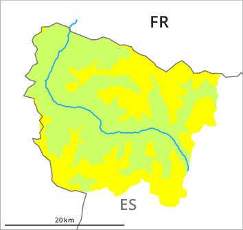
2300m
Avalanche Problem

Wind-drifted snow

2300m

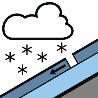
New snow

With immediate effect, the avalanche danger will be assessed twice a day (at 8 am and 5 pm).
Fresh wind slabs represent the main danger.
Gradual increase in danger of dry avalanches as a consequence of new snow and wind. In the course of the day danger level 2 (moderate) will be reached above the tree line.
Adjacent to ridgelines on east and south facing slopes the wind slabs will increase in size from late morning. These can in some places be released by a single winter sport participant and reach medium size. The avalanche prone locations are to be found in particular adjacent to ridgelines and in pass areas above approximately 2300 m. They are barely recognisable because of the poor visibility.
The new snow is bonding poorly with the old snowpack in particular on very steep west and north facing slopes above approximately 2000 m. The avalanches in these loacations are only small but in many cases easily released.
Backcountry touring and other off-piste activities call for meticulous route selection.
Snowpack
>15 to 20 cm of snow will fall until the evening in all altitude zones. The new snow will be deposited on soft layers in all aspects above approximately 2000 m. The wind will be moderate to strong adjacent to ridgelines.
Below approximately 2000 m from a snow sport perspective, in most cases insufficient snow is lying. At higher altitudes there are 40 to 60 cm of snow, but less in some localities.
Below approximately 2000 m from a snow sport perspective, in most cases insufficient snow is lying. At higher altitudes there are 40 to 60 cm of snow, but less in some localities.
Tendency
Further increase in danger of dry avalanches as the snowfall becomes more intense.