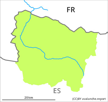
Danger level
Avalanche Problem

Wind-drifted snow


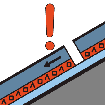
Persistent weak layer

2000m

A generally favourable avalanche situation will prevail. Fresh and older wind slabs represent the main danger.
⚠ Error: Línia desconeguda 594 en im_Gebiet!
Snowpack
>
2 to 5 cm of snow fell in the past few hours above approximately 1300 m. Up to 5 cm of snow, and up to 10 cm in some localities, will fall until the early morning in all altitude zones. The northwesterly wind will transport only a little snow.
Shady slopes: The old snowpack will be soft over a wide area. It is faceted; its surface consists of loosely bonded snow.
Sunny slopes: The surface of the snowpack has frozen to form a strong crust and will hardly soften at all.
Shady slopes: The old snowpack will be soft over a wide area. It is faceted; its surface consists of loosely bonded snow.
Sunny slopes: The surface of the snowpack has frozen to form a strong crust and will hardly soften at all.
Tendency
Saturday: Slight increase in danger of moist snow slides as a consequence of warming during the day and solar radiation. The danger of dry avalanches will not decrease for the time being.