Danger level

2100m
Avalanche Problem

Wind-drifted snow

2100m


Wet snow

1800m


Fresh wind slabs represent the main danger. Moist snow slides and avalanches as the day progresses.
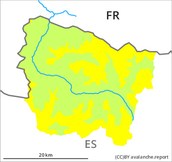
As a consequence of new snow and a sometimes strong northwesterly wind, avalanche prone wind slabs formed in the last two days in all aspects. The fresh wind slabs can over a wide area be released by people or triggered naturally. These avalanche prone locations are to be found in particular adjacent to ridgelines and in gullies and bowls in north to east to south facing aspects above approximately 2100 m. In particular on steep, little used north and east facing slopes they can be released easily and reach medium size in some cases. By the early morning the wind slabs will increase in size additionally.
As a consequence of warming during the day and the solar radiation, the likelihood of moist snow slides and avalanches being released will increase significantly on very steep sunny slopes at intermediate and high altitudes. They are rather small but easily released.
Backcountry touring and other off-piste activities call for careful route selection. The wind slabs are to be bypassed in particular in very steep terrain. Apart from the danger of being buried, restraint should be exercised as well in view of the danger of avalanches sweeping people along and giving rise to falls.
Snowpack
>
Up to 10 cm of snow, and up to 15 cm in some localities, fell on Saturday above approximately 1500 m. Monday: Some snow has fallen. The sometimes storm force wind has transported the new snow significantly. The new snow and wind slabs are poorly bonded with the old snowpack in particular on very steep north and east facing slopes at intermediate and high altitudes. Released avalanches and field observations indicate the unfavourable bonding of the snowpack in particular on wind-loaded slopes. As a consequence of sharply rising temperatures and solar radiation a sometimes precarious avalanche situation will develop in the course of the day.
Above approximately 2000 m there are 100 to 200 cm of snow, and even more in some localities. Snow depths vary greatly at elevated altitudes, depending on the infuence of the wind.
Above approximately 2000 m there are 100 to 200 cm of snow, and even more in some localities. Snow depths vary greatly at elevated altitudes, depending on the infuence of the wind.
Tendency
Wednesday: The danger of dry slab avalanches will decrease gradually. The danger of moist avalanches will decrease gradually, but only during the night.