AM
Danger level

Avalanche Problem

Wet snow


Wind slab

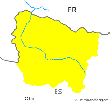
2300m

PM
Danger level

Avalanche Problem
Wet snow

Wind slab
2300m
Wet snow represents the main danger. Wind slabs at high altitude.
As the day progresses as a consequence of warming there will be a gradual increase in the danger of moist avalanches to level 3 (considerable). Sometimes the moist avalanches are medium-sized. The old wind slabs can still be released in some cases in particular on extremely steep, little used shady slopes and at elevated altitudes, especially at their margins. Sometimes they are medium-sized. In addition further wind slabs will form in particular on north and northeast facing slopes and at elevated altitudes as the day progresses. In particular at the border to Benasque and at the border to Ribagorça and Pallars the avalanche prone locations are more prevalent and the danger is greater. In addition a latent danger of gliding avalanches exists.
The current avalanche situation calls for meticulous route selection. Backcountry tours and off-piste skiing should be concluded by around midday.
The current avalanche situation calls for meticulous route selection. Backcountry tours and off-piste skiing should be concluded by around midday.
Snowpack
>
The avalanche conditions remain spring-like. The hard wind slabs have bonded quite well with the old snowpack. Outgoing longwave radiation during the night will be reduced. Sunshine and high temperatures will give rise as the day progresses to increasing moistening of the snowpack over a wide area in all aspects. The sometimes strong wind will transport the snow.
Above approximately 2000 m there are 40 to 120 cm of snow, and even more in some localities. At high altitudes and in high Alpine regions snow depths vary greatly, depending on the infuence of the wind.
Above approximately 2000 m there are 40 to 120 cm of snow, and even more in some localities. At high altitudes and in high Alpine regions snow depths vary greatly, depending on the infuence of the wind.
Tendency
Hardly any decrease in danger of moist and wet avalanches until the temperature drops.