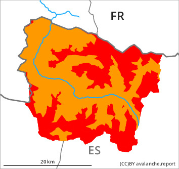
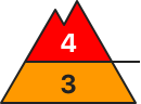
Danger level
treeline
Avalanche Problem

Wind slab

Treeline


Persistent weak layer
2000m

More snow than expected has fallen over a wide area.
The avalanche conditions are critical. New snow and wind slabs in all aspects. Weakly bonded old snow on shady slopes.
The new snow and wind slabs can be released easily or naturally in all aspects. In all regions the already large wind slabs will increase in size during the course of the night. Especially transitions from a shallow to a deep snowpack, shady slopes: Dry avalanches can also be triggered in the old snowpack and reach large size.
In particular low altitudes and steep sunny slopes: As a consequence of warming during the day and solar radiation dry and moist snow slides are to be expected as the day progresses, in particular medium-sized ones. Individual gliding avalanches can also occur.
Backcountry touring and other off-piste activities call for extensive experience in the assessment of avalanche danger.
Snowpack
>
Saturday: Over a wide area 30 cm of snow has fallen above approximately 1500 m. 10 to 15 cm of snow will fall in the next few hours in all altitude zones. The northwesterly wind will transport the new snow significantly.
Sunday: The weather will be sunny at times. The southwesterly wind will transport the snow.
Distinct weak layers exist in the bottom section of the old snowpack in particular on rather lightly snow-covered west, north and east facing slopes. Released avalanches and stability tests confirm the complex avalanche situation in all regions.
At intermediate altitudes there are 100 to 150 cm of snow, and even more in some localities. At elevated altitudes snow depths vary greatly, depending on the infuence of the wind.
Tendency
Monday: 20 to 40 cm of snow will fall until the early morning in all altitude zones. The avalanche danger will increase but remain within the current danger level.