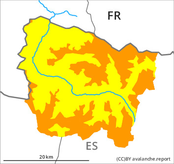
Danger level

treeline
Avalanche Problem

Wind slab

Treeline


Wet snow
2300m
The wind slabs represent the main danger.
Evening and night:
As a consequence of the rain small and, in isolated cases, medium-sized moist snow slides are possible below approximately 2300 m. Gliding avalanches are also to be expected.
Thursday:
As a consequence of new snow and a strong to storm force northwesterly wind, extensive wind slabs will form adjacent to ridgelines and in gullies and bowls as well as above the tree line. Avalanches can be released by people or triggered naturally. Over a wide area they will increase in size substantially as the day progresses. In particular very steep shady slopes areas where the snow cover is rather shallow: Additionally avalanches can be released in the old snowpack. In particular at high altitudes and in high Alpine regions the avalanches are in some cases large.
Snowpack
>
Evening and night: The rain will give rise to increasing moistening of the snowpack over a wide area in all aspects below approximately 2300 m.
Thursday: The surface of the snowpack will freeze to form a strong crust and will hardly soften at all. The weather will be partly cloudy over a wide area. 2 to 5 cm of snow will fall until the afternoon in all altitude zones. The strong wind will transport the new snow and, in some cases, old snow as well.
The rain gave rise to significant settling of the snowpack at low and intermediate altitudes. Large-grained weak layers exist in the bottom section of the old snowpack in particular on shady slopes. At intermediate altitudes there are 100 to 180 cm of snow, and even more in some localities.
Tendency
Friday: Slight increase in danger of dry avalanches as a consequence of the snowfall.