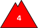
Danger level
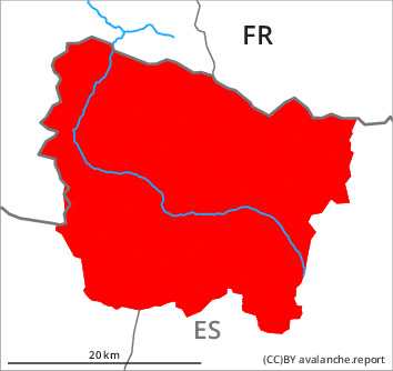
treeline
Avalanche Problem

Wind slab

Treeline


New snow

Over a wide area 50 to 60 cm of snow has fallen. The northwesterly wind has transported the new snow significantly.
New snow and wind slabs are to be critically assessed. The avalanches can occur easily or triggered naturally.
As a consequence of new snow and a strong northwesterly wind, large surface-area wind slabs formed adjacent to ridgelines and in gullies and bowls as well as at intermediate and high altitudes. The avalanche-prone wind slabs are lying on unfavourable layers in all aspects. They are in some cases large. Especially rather lightly snow-covered shady slopes, high altitudes: In isolated cases avalanches can be released in the old snowpack and reach very large size.
Also steep slopes in places that are protected from the wind: As a consequence of warming snow slides and avalanches are to be expected as the day progresses, in particular medium-sized ones. Large avalanches are further not ruled out.
In particular low altitudes, very steep grassy slopes: Individual gliding avalanches can also occur.
The avalanche prone locations are numerous and are barely recognisable because of the poor visibility. The conditions are unfavourable for backcountry touring.
Snowpack
>
A great many medium-sized and, in isolated cases, large dry avalanches have been released as a consequence of new snow and strong wind. Shooting cracks when stepping on the snowpack and fresh avalanches confirm the unfavourable bonding of the snowpack on all slopes.
Some snow will fall on Sunday. The weather will be cloudy. The northwesterly wind will transport the new snow.
Over a wide area new snow and wind slabs are lying on soft layers. Faceted weak layers exist in the bottom section of the snowpack in particular on shady slopes. At intermediate altitudes there are 150 to 220 cm of snow, and even more in some localities.
Tendency
Monday: Slight increase in danger of dry and moist avalanches as a consequence of the precipitation.