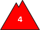
Danger level
2000m
Avalanche Problem

Wind slab

2000m


Wet snow
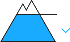
2000m
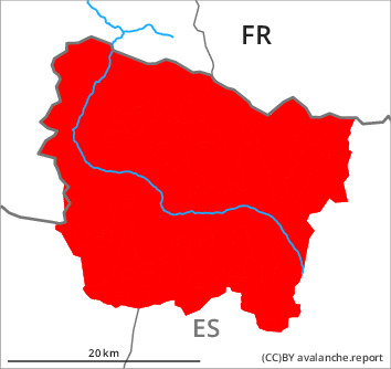
The avalanche conditions are critical.
New snow and wind slabs. Low and intermediate altitudes: Gradual increase in danger of moist avalanches.
The wind slabs of the weekend can be released by a single winter sport participant in some cases. They will be covered with new snow and therefore difficult to recognise. As a consequence of new snow and a moderate northwesterly wind, further wind slabs will form from late morning adjacent to ridgelines and in gullies and bowls as well as at intermediate and high altitudes. They are sometimes large.
Steep slopes in places that are protected from the wind: As the snowfall becomes more intense dry snow slides and avalanches are to be expected, in particular medium-sized ones.
The dry avalanches can occur easily or triggered naturally.
In particular low and intermediate altitudes: As the penetration by moisture increases moist avalanches are to be expected, even large ones. Especially rather lightly snow-covered shady slopes intermediate altitudes: In isolated cases avalanches can be released in the old snowpack and reach dangerously large size. Gliding avalanches are also to be expected.
The avalanche prone locations are numerous and are barely recognisable because of the poor visibility.
Snowpack
>
Monday: The weather will be very cloudy. 30 to 40 cm of snow, and even more in some localities, will fall until the afternoon. Up to 2000 m rain will fall over a wide area. The northwesterly wind will transport the new snow.
In some places new snow and wind slabs are lying on soft layers. The rain will give rise to increasing moistening of the snowpack in all aspects. Faceted weak layers exist in the bottom section of the snowpack in particular on shady slopes. At intermediate altitudes there are 150 to 220 cm of snow, and even more in some localities.
In some places new snow and wind slabs are lying on soft layers. The rain will give rise to increasing moistening of the snowpack in all aspects. Faceted weak layers exist in the bottom section of the snowpack in particular on shady slopes. At intermediate altitudes there are 150 to 220 cm of snow, and even more in some localities.
Tendency
Tuesday: The avalanche danger will persist.