EARLIER
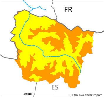
Danger level

treeline
Avalanche Problem

Wind slab

Treeline


Wet snow
2400m

LATER
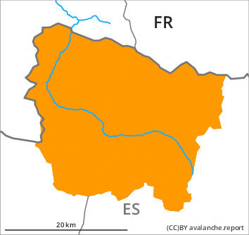
Danger level

2400m
Avalanche Problem
Wet snow
2400m
Wind slab
Treeline
The extensive wind slabs of the last few days must be evaluated with care and prudence in all aspects. From the middle of the day, wet avalanches are to be expected.
The fresh and somewhat older wind slabs can be released very easily in all aspects and above the tree line. The avalanche prone locations are to be found especially in gullies and bowls, and behind abrupt changes in the terrain and in the vicinity of peaks. In some cases the avalanches are medium-sized. In isolated cases avalanches can reach large size.
Midday and afternoon: From the middle of the day the likelihood of moist and wet avalanches being released will increase quickly on steep sunny slopes below approximately 2400 m. Small and medium-sized natural avalanches are to be expected. Gliding avalanches can also occur.
Backcountry touring and other off-piste activities call for extensive experience in the assessment of avalanche danger and careful route selection.
Snowpack
>
The weather will be sunny. Over a wide area 15 to 20 cm of snow, and even more in some localities, has fallen since Thursday above approximately 1500 m.
The fresh snow and in particular the sometimes deep wind slabs are lying on the unfavourable surface of an old snowpack. Faceted weak layers exist in the bottom section of the snowpack in particular on shady slopes.
Sunshine and high temperatures will give rise from the middle of the day to increasing moistening of the snowpack especially on steep sunny slopes below approximately 2400 m.
There is more snow than usual. At intermediate altitudes there are 150 to 220 cm of snow, and even more in some localities.
Tendency
Sunday: Further increase in danger of moist avalanches as a consequence of warming during the day and solar radiation.