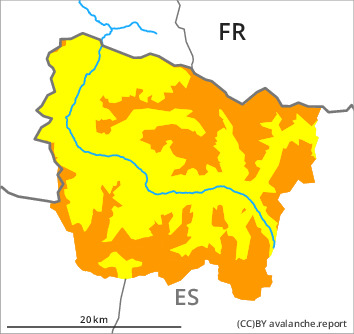
Danger level

2000m
Avalanche Problem
Gliding snow

2000m


Wet snow

The Avalanche Warning Service currently has only a small amount of information about the snowpack, so that the avalanche danger should be investigated especially thoroughly in the relevant locality.
Gliding snow is to be avoided. Wet snow slides and avalanches as the day progresses.
An acute danger of gliding avalanches exists. In many cases the avalanches are medium-sized. Some large avalanches are further not ruled out. The avalanche prone locations are to be found especially on steep shady slopes at intermediate and high altitudes. Areas with glide cracks are to be avoided. They can be released at any time of day or night.
From the early morning as the penetration by moisture increases there will be a gradual increase in the danger of wet avalanches. In all aspects small and medium-sized snow slides and avalanches are possible. These can be released by people or triggered naturally. Intermediate altitudes, shady slopes: Avalanches can in isolated cases penetrate deep layers and reach large size.
Backcountry tours should be started and concluded very early.
Snowpack
>
Outgoing longwave radiation during the night will be reduced. The surface of the snowpack will only just freeze and will already soften in the late morning. In the early morning the weather will be mostly sunny. Up to 2800 m rain will fall in the afternoon in some regions.
The snowpack will be generally wet all the way through. Steep west, north and east facing slopes, intermediate and high altitudes: Several medium-sized and large gliding avalanches have been released in the last few days.
On southwest, south and southeast facing slopes at intermediate altitudes from a snow sport perspective, insufficient snow is lying. Over a wide area a lot of snow is lying for the time of year.
Tendency
Friday: The danger of wet and gliding avalanches will persist.